 Marinate
Routes & Planning
Plot the passage. Then sail it.
Build a route leg by leg, save the places that matter with photos and notes, and let active Go-To navigation walk you down the plan — distance to waypoint, bearing, ETA, VMG and cross-track error, live on the chart.
Route planning, Go-To navigation, markers, GPX and sharing are all part of the free core. No account needed.

Multi-leg routes
A passage plan that lives on the chart
Tap the chart to drop waypoints and Marinate strings them into a route, one leg after another. Rearrange, extend or trim the plan until the line on the chart is the passage you actually want to sail.
Because Marinate is offline-first, the route you plan at the dock is the route you carry offshore — no signal required once your chart area is downloaded.
- Leg-by-leg planning — build routes from as many waypoints as the passage needs.
- Measure tool — check any distance or bearing on the chart before you commit it to the plan.
- Works offline — plan and navigate with charts downloaded per area.
- GPX in, GPX out — routes, waypoints and tracks move freely between devices and apps.
Waypoints & markers
Remember every spot worth returning to
Drop a marker anywhere and give it a photo and a note. Six marker types keep your chart readable at a glance — and every one of them stays on your device.
Anchorage
Mark the bay that held in that southerly, with a photo of the transit and a note on the bottom.
Fishing
Keep productive marks private and precise — position, notes and photos, stored only on your device.
Hazard
Note the uncharted rock or the shoaling patch so it stands out the next time you pass.
Marina
Save berths and harbours with the details you'll want on approach — photos included.
Dive
Pin wrecks and reef sites, and keep your own notes on conditions and entry points.
Waypoint
The plain mark — drop one as a quick Go-To target, or string a chain of them into tonight's route.
Active Go-To
Navigation that keeps score
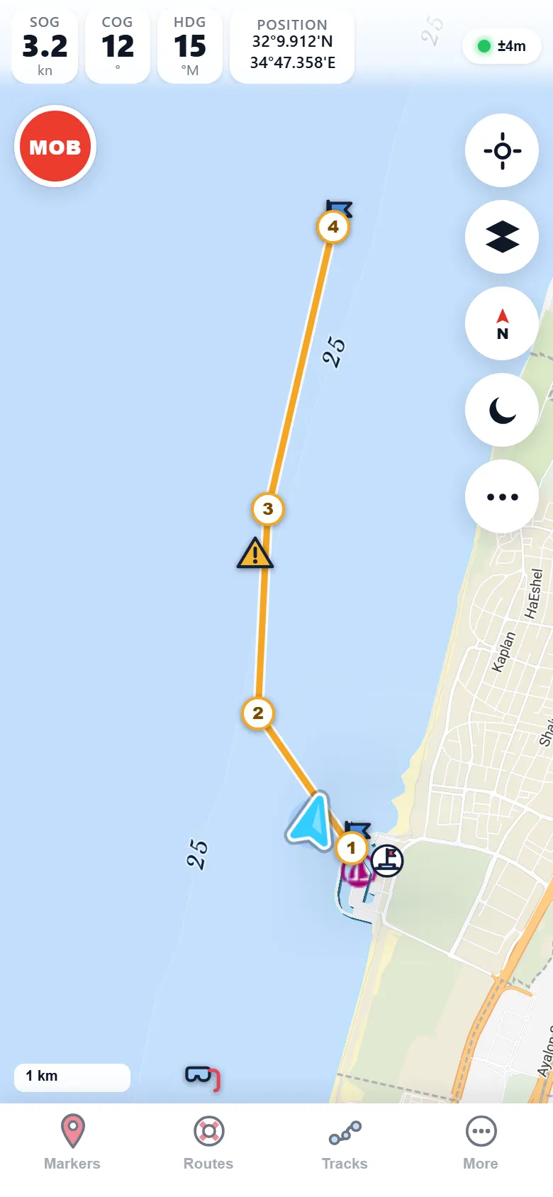
Activate a route — or a single Go-To — and Marinate turns the plan into live guidance: distance to waypoint, bearing, ETA and VMG, computed from your GPS position as you sail.
A cross-track error ribbon shows how far you've drifted off the leg and which way to steer back. Reach a waypoint and Marinate advances to the next leg automatically, so your hands stay on the helm, not the screen.
The same numbers as the screen beside it: 1.61 NM to WP2 along the 008° first leg — bearing 8°, just 19 m starboard of the line.

Share & move data
Your routes are yours to carry anywhere
Marinate speaks GPX, the common language of navigation apps and plotters — and it can share a whole passage in a single link, without touching a server. Sharing stays as private as the rest of the app: your routes live on your device, and a link only contains what you chose to share.
GPX import
Bring routes, waypoints and tracks in from other apps or a plotter. They land on the chart, ready to edit and sail.
GPX export
Send your plan to a backup, a crewmate or another device as a standard GPX file. No lock-in, ever.
Serverless deep links
Share a route as a link that carries the data inside it. Whoever opens it gets the passage — no server, no account, no upload.
Pilot book
Your own port & anchorage pilot book
Marinate keeps a pilot book of ports and anchorages, and it can import harbour information straight from OpenSeaMap to give you a head start. Add your own entries as you cruise, and pair them with the anchorages, marinas and notes already on your chart.
- Ports and anchorages — collected in one browsable pilot book.
- OpenSeaMap harbour import — pull in community harbour data with a tap.
- Grows with your log — the places you mark become the guide you sail by.

Questions
Planning, answered
Does route planning work offline?
Can I bring routes from another app or plotter?
How can link sharing work without a server?
Is any of this behind the paywall?
Ready about — helm's a-lee
Plan tonight, sail tomorrow
Marinate is on the App Store and Google Play. The core is free forever — plot your first route the day you install it.